Dry River Revisit
This is a report of a hike to explore Dry River Wilderness where I got lost on November 3, 2007.
Date: 2008-11-02
Total distance: 17.1 miles (27.5 km)
Total Time: 9 hours 27 minutes
Start elevation: 1900 ft (579 m)
End elevation: 1900 ft (579 m)
Total Ascent: 6665 ft (2031 m) (Per Garmin Forerunner 301 GPS watch)
| Time | Landmark | Elevation | Cumulative Distance | Following Trail | Distance Interval | |||
| (foot) | (m) | (mile) | (km) | (mile) | (km) | |||
| 07:45:00 AM | AMC Highland Center | 1900 | 579.1 | 0 | 0.0 | Crawford Path | 1.9 | 3.1 |
| 08:34:00 AM | Mizpath Cutoff | 3380 | 1030.2 | 1.9 | 3.1 | Mizpath Cutoff | 0.7 | 1.1 |
| 08:59:00 AM | Mizpath Spring Hut | 3800 | 1158.2 | 2.6 | 4.2 | Mount Clinton Trail | 0.5 | 0.8 |
| 09:19:00 AM | Dry River Cutoff | 3425 | 1043.9 | 3.1 | 5.0 | Mount Clinton Trail | 2.5 | 4.0 |
| 10:52:00 AM | Dry River Trail | 1900 | 579.1 | 5.6 | 9.0 | Dry River Trail | 2 | 3.2 |
| 12:28:00 PM | Isolation Trail | 2600 | 792.5 | 7.6 | 12.2 | Dry River Trail | 0.3 | 0.5 |
| 12:36:00 PM | Mt Eisenhower Trail | 2650 | 807.7 | 7.9 | 12.7 | Dry River Trail | 0.4 | 0.6 |
| 12:50:00 PM | Last Dry River Crossing | 2850 | 868.7 | 8.3 | 13.4 | Dry River Trail | 0.4 | 0.6 |
| 01:09:00 PM | Mt Eisenhower Trail | 2650 | 807.7 | 8.7 | 14.0 | Mt Eisenhower Trail | 0.3 | 0.5 |
| 01:30:00 PM | Dry River Cutoff | 2650 | 807.7 | 9 | 14.5 | Mt Eisenhower Trail | 2.4 | 3.9 |
| 02:55:00 PM | Crawford Path | 4475 | 1364.0 | 11.4 | 18.3 | Crawford Path | 0.3 | 0.5 |
| 03:09:00 PM | Edmands Path | 4450 | 1356.4 | 11.7 | 18.8 | Edmands Path | 2.9 | 4.7 |
| 04:28:00 PM | Mt. Clinton Road | 2000 | 609.6 | 14.6 | 23.5 | Mt. Clinton Road | 2.5 | 4.0 |
| 05:12:00 PM | AMC Highland Center | 1900 | 579.1 | 17.1 | 27.5 | |||
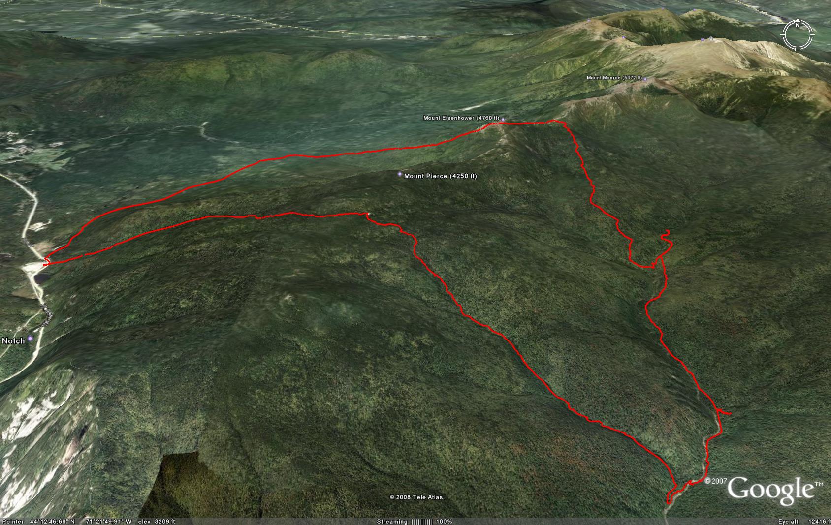
The following is a picture from Google Earth which does not reflect the weather condition of the hike. More pictures are at Picasa.
Prologue
I got lost in the Dry River Wilderness on Saturday November 3, 2007 resulting in a long exhausting bushwhacking night. I had been thinking about going back to understand the wilderness and find answers to many questions I had regarding the Dry River Trail that humbled me. I tried once in May and could not cross the river due to high water. Since I needed to revisit the critical spots in the bushes, I wanted to go there when many trees have lost their leaves and branches making bushwhacking easier, but it needs to be before the snow covers the ground. November is a good time, but the window is only two or three weeks wide. On October 31 night, I checked the weather and found White Mountains were dry and the weather would relatively good. I decided to go there to conduct my investigation. Originally I wanted to have a 18 to 20 miles long hike starting from the Highland Center. Since the Dry River Trails has so many unknowns to me, I decided to split it into two – a short one to explore the lower part on Saturday afternoon then a longer one to explore the upper part on Sunday. This turned out to be a very wise decision.
The Journey
I left home at 10:50 and stopped by a new Chinese restaurant on Rt. 16 – Wonton Chinese Restaurant – to get a Singapore Noodle which was very well cooked. I reached the trailhead of the Dry River Trail at 14:10 and started the hike immediately. My GPS watches were not able to acquire satellite signals until I reached the suspension bridge which is about 1.7 miles into the trail. I loaded my last year's hike path into my Garmin Forerunner 205 to help me find the critical spot and I used my Garmin Forerunner 305 as the normal course recorder. The bridge was damaged in 2005 and was yet to be fixed. At the bridge when both of my GPS watches had acquired satellite signals, I found I was not far from the spot when I turned on my GPS watch, which was running out battery, to get some light after I lost my flashlight. That is the last spot in the wilderness recorded. I did not try to cross the river to follow the Dry River Trail,instead, I stayed on the west bank of the river to approach the spot. I finally found the spot and the two big trees that I sit against and fell asleep for the last time. They are high and far from the river. What happened one year ago played back vividly like a movie in my mind. I realized the difficulty in bushwhacking came largely from darkness. When it is bright, it is not difficult to find paths with little obstruction from tree branches and relatively flat. I still believe the decision to ascend from that spot to reach Rt. 302 on the other side of the ridge was a good one. If I had continued bushwhacking on the west bank of Dry River, I am not sure, I would have been able to see the suspension bridge. Even if I would have seen it, it would have been very difficult to follow the Dry River Trail after the bridge due to a sharp up right turn. Actually, on my return I missed the turn and had to come back to find it under bright daylight.
After taking quite a few pictures, I continued easy bushwhacking on the west bank and looking for a spot to cross the river. After crossing three tributaries, I found a spot with relative safe boulder hopping to cross the river. I did successfully. It took quite a few minutes to find the Dry River Trail after crossing the river because the trail at that spot was quite far and high from the river bed. Once I found it, it was very easy to follow. It seemed to be well traveled and the trail is quite clear and relatively flat probably due to the fact it is on the old log railway grade. I reached the junction of Mount Clinton Trail at 16:00. I checked the crossing and found it was not easy. This made me wonder whether I should come from this trail the next day. Since it would get dark by 18:00, I started my return without wasting time. I started to explore water crossing at the spot where I crossed from the west bank. The reverse crossing would be difficult because I would have to jump up at the critical hop instead of jumping down which I did when crossing it a shore while ago. I continued to search alternatives. I found one spot seemingly doable. Unfortunately I slipped into the water and got my both feet wet. I stayed on the trail for about a quarter of a mile and finally found a spot where one can keep feet dry while letting the boots wet to cross the river. I did it successfully. Actually I was already ready to wade across the water since my feet were already wet. Once I crossed the river, I took off my boots and socks to dry them by hand as much as I could. Very soon I reached the suspension bridge. I got back to my car on Rt. 302 at 17:10 and reached the Highland Center at 17:20. Surprisingly the dinner had already started. Later I learnt that due to the annual Old Hutter event, the dinner started at 17:00 so the 100+ hutters could have their dinner after other guests finished. The buffet dinner was very good, especially, the soup. The dessert was also delicious. The front desk staffer kindly lent me a shoe dryer to dry my boots. I browsed Internet by using the AMC's WiFi and watched a video of amazing mountain biking before going to bed.
I was the only occupant of my room, quite normal during slow season. I got up at about 5:30 after a good night of sleep. The 7th grade of Franklin D Roosevelt School were there. They were behaving very well. I was waken up only once by them.
After a hearty breakfast, I packaged all of my items and put them into my car then started the long hike at 7:45, about half an hour later than I planned. It was cold, but as expected, soon after ascending I felt very warm. The Crawford Path is always well traveled. Mizpath Cutoff was very icy. I met a large group of hikers who camped at Nauman Tentsite the night before and was coming down. They told me the trails were quite icy all the way to the summits. I chatted with another hiker after reaching Mizpath Spring Hut at about 9:00. He heard of 6 inch snow near Mt. Washington. This made me start rethinking about my plan of going up the the Lakes of the Clouds. I read about the Mt. Clinton Trail in AMC's White Mountain Guide very carefully the night before. According to the guide, this trail is very lightly traveled and difficult to follow. I found the trail is well traveled for about 0.5 miles to the junction of the Dry River Cutoff. After that, it is very lightly traveled, but it was surprisingly easy to follow until the last mile. In most part, the trail is a brook by itself and parallel and close to a major brook. If one knows which side of the brook this trail is on, it is easy to retrieve the trail if lost. I did get lost after a few crossings of the major brook, but fortunately I found the trail at the last crossing and this one is important because the trail goes high and far from the brook after this crossing. The last 0.1 or 0.2 miles looked very familiar. I believe I found this part a year ago when I saw a cairn at the crossing part but I did not dare to crossing. That was the right decision because as a novice White Mountain hiker at that time, I would have had difficulty in finding the trail on the other side of the river or following it. I reached the river at 10:52.
I started searching for an easy crossing spot and gave up after bushwhacking for about a quarter of a mile. I decided to pole vault me into a relatively shallow spot with my hiking poles. I took off my shoes and socks and threw them to the east bank of Dry River. My pole vaulting was a complete failure. Everything was slipping. Frigid waist deep water reached my chest. After getting on the bank, I had to strip myself completely as quickly I could. I am so glad that I had extra pants and shirt. The bottom of my right foot was hurt badly somehow. I did not have an extra pair of briefs so I had to wear it and dry it with my body. I put on my water proof ski pants and they turned out to be superb comfortable. I left the wet pants and T-shirt on my backpack and eventually they turned ice sheets bouncing on my back.
Once I got on the Dry River Trail, it was quite easy to follow. This certainly has to do with so many long hikes I had had since I got lost on this trail a year ago. My getting lost was primarily caused by my lack of experience. Even by this time, I was confused by a campsite sign which I mistook as an arrow sign pointing to the direction of the trail. I reached the Isolation Trail at 12:28 and reached the last river crossing of the Dry River Trail at 12:50. I stood on a rock in the middle of the river and noticed the river crossing was very easy but I did not cross. This is the spot where I got lost. I was coming from the other side - west bank. I could not find the trail on the east bank. After many hikes in the White Mountains since the incident, the trails on both banks looked very conspicuous to me now. By this time, I had already made up my mind to abandon my plan A - reaching the Lakes of the Clouds and hiking back to the Crawford Center. The Lakes of the Clouds is 4.4 miles away with about 2500 feet elevation gain. If I had gone there, I would have had less than one hour daylight left. The 6 inch snow I heard earlier also made me leery of the high elevation. I decided to execute plan B - taking the 2.7-mile Mt. Eisenhower Trail to the Crawford Path.
I backtracked about half a mile to reach the Mt. Eisenhower Trail at 13:09. The river crossing was fairly easy though I had to get my boots wet. I saw another campsite sign immediately after crossing the river and this time I was not misled by it and took the right path to reach the junction of the Dry River Cutoff at 13:29. The Mt. Eisenhower Trail is very easy to follow, the climbing is steady and moderate most of the time. I ran across a hiker coming down from the summit. We chatted a little bit. He came up from the trailhead of the Dry River Trail and used the closed suspension bridge to cross the river. I should have used that bridge. Even if it collapses, it would not be very risky because the bridge is not very high above the water.
I reached the Crawford Path at 14:55 and saw 3 hikers from Montreal. I meet people from Montreal almost every time I hike in the White Mountains. They camped at the Mizpath Spring Hut the night before and hiked to Mt. Washington Summit and was going down to the Highland Center where they parked their car. The Crawford Path was covered with a thin layer of snow offering some cushion and traction. They told me it was pretty much like this all the way to the summit of Mt. Washington. It looked like a good day for Presi Traverse. With only an hour or so daylight left, I switched to plan C - taking the 3-mile Edmands Path to the Mt. Clinton Road (an auto road) instead of taking hiking 4.3 miles on the Crawford Path with traversing the icy section in the dark. This turned out to be a very good decision. The three Montreal hikers decided to stick to their plan of hiking the Crawford Path. They apparently dislike walking on a auto road. I do too but safety outweighs pleasure.
The first 1.5 miles of the Edmands Path was very icy but the rest was very comfortable. I reached the Mt. Clinton Road at 16:28 a moment after watching sunset. This is an auto road mainly for hikers so it has very little traffic. I saw only three vehicles during the 2.5-mile walk before reaching Rt. 302 at 17:00 and my car at 17:02. It was almost dark enough to require headlamp that I managed to avoid using. Switching to Plan C was undoubtedly a wise decision.
Epilogue
I stopped by my favorite restaurant in North Conway - China Chef - to have my lunch-and-dinner. I ordered an exotic drink for the first time without much knowledge about it. It tasted poorly for me and the waiter confirmed it had alcohol. It was my first time over more than a decade to have any alcohol which never tastes good to me unless I am drunk after drinking too much. I reached home at about 21:00.
